
Plan specific cycling routes in Slovakia
Routes differ in more than length: the overview shows loops, point-to-point routes with separate starts and finish points, an approach to a destination, and two valley sections. Elevation gain and surface help you assess the level of challenge. The figures are route profiles as given in the respective descriptions; for point-to-point routes, a return journey is not included in the stated distance.
Map: 13 starting locations for 14 cycling routes
First choose on the map the area where you would like to start. The 13 numbered markers represent 14 routes: in the Trenčín area, two loop routes are listed under number 3. Each marker indicates the starting area, not the exact route. Then find the same number in the table. There you can compare routes in your area by distance, elevation gain and route type, and weigh up the details that matter to you side by side.
Click to share
Routes compared: distance, ascent and surface
The distance in kilometres tells you how long a route is; elevation gain provides another indication of its profile. Also take the stated surface and rating—easy, moderate or difficult—into account when comparing routes. Two routes of the same length can differ considerably: the 44-kilometre route from Devín through the March plain is described as easy, with 10 metres of elevation gain. The point-to-point route from Gemerská Hôrka to Silica is also 44 kilometres long, but includes 719 metres of elevation gain and is rated difficult. Domica Cave is a destination along this route.
| Route · Start & finish | Distance | Ascent | Difficulty | Highlights |
|---|---|---|---|---|
| Cycling loop around Slovak Paradise1 Spišská Nová Ves–Spišská Nová VesLoop | 74 km | 870 m | difficult | Forest route with two steep climbs |
| Cycling route around Veľký Choč2 Dolný Kubín–Dolný KubínLoop | 44 km | 570 m | moderate | Two climbs between Orava and Liptov; busy road |
| Cycling loop through Súčanské kopanice3 Trenčín–TrenčínLoop | 34 km | 380 m | moderate | Hamlets in Považské Podolie and the White Carpathians; two steep climbs |
| Cycling route through the March plain4 Devín–DevínLoop | 44 km | 10 m | easy | Paved; section along the March nature trail |
| Cycling loop through the Trenčín Basin3 Trenčín–TrenčínLoop | 56 km | 180 m | easy | Sections of the Váh cycling route; nature and history stops |
| Cycling route above Zádielská Gorge5 Zádiel–RožňavaPoint-to-point route | 54.5 km | 950 m | difficult | Cycling route along the upper edge of the gorge; the narrow valley path is reserved for hikers |
| Cycling route near Domica6 Gemerská Hôrka–SilicaPoint-to-point route | 44 km | 719 m | difficult | Slovak Karst; Domica and Gombasecká jaskyňa caves along the route |
| Cycling route through the Tichá and Kôprová valleys7 Podbanské as start and finish pointTwo valley sections19 km across the indicated sections | 19 km | 510 m | moderate | 11 km in the Tichá section and 8 km in the Kôprová section; Tichá: 250 m ascent over 8 km |
| Cycling loop around Zobor8 Nitra–NitraLoop | 35 km | 242 m | moderate | Roads and firm forest tracks; Nitra Castle and the Romanesque church in Dražovce |
| Cycling loop through Burda9 Štúrovo–ŠtúrovoLoop | 30.5 km | 94 m | easy | Forest track can be slippery after rain; not suitable for road bikes |
| Cycling route to Popradské pleso10 Cesta slobody at the Tatra railway–Popradské plesoApproach to destination | 4 km | 290 m | moderate | Steep climb through the Mengusovská Valley to 1,494 m |
| Challenging cycling loop through lower Liptov11 Ružomberok–RužomberokLoop | 58 km | 606 m | Expert | Liptov villages; one steep climb and busier road sections |
| Freedom cycling route through the High Tatras12 Liptovský Hrádok–KežmarokPoint-to-point route | 68 km | 700 m | difficult | Connection between Tatra towns with one abrupt climb |
| Cycling route through the Poprad Gorge13 Stará Ľubovňa–Stará ĽubovňaLoop | 51 km | 555 m | difficult | Along the border river; six kilometres unpaved |
Six routes compared by distance and elevation gain
The bar chart compares six selected routes by distance and ascent. Kilometres and metres of elevation gain each have their own scale. So read each bar together with its unit and consider both figures side by side: distance indicates the route length, while elevation gain adds information about the climb. This lets you compare the route profiles shown and then check them against the surface and difficulty information.
Click to share
Loop or separate start and finish locations?
On a loop, the start and finish are in the same place. A point-to-point route, by contrast, starts and ends in different places, so include the destination in your plans. If you want to return to your starting point on a point-to-point route, add the return journey to the stated one-way distance. Also check whether a figure refers to the whole route or only selected sections. The climb to Popradské pleso is listed as 4 kilometres to the destination and 290 metres of elevation gain; for a trip that includes a return, add the corresponding return distance. The 19 kilometres for Tichá and Kôprová consist of two selected valley sections of 11 and 8 kilometres. Your total distance for the day depends on the sections you actually choose and the corresponding return journeys.
Two different cycling loops starting from Trenčín
Near Trenčín, you can compare two loop routes with different profiles. The loop through the Trenčín Basin is 56 kilometres long, has 180 metres of elevation gain and is rated easy. The loop through Súčanské kopanice covers 34 kilometres and 380 metres of elevation gain; two steep climbs make it moderately challenging. For comparison, there is also the shorter route to Popradské pleso, which is 4 kilometres long with 290 metres of elevation gain. Then decide whether a loop or destination, distance, ascent or surface matters most to you.
Slovakia: Map of cycling route starting areas
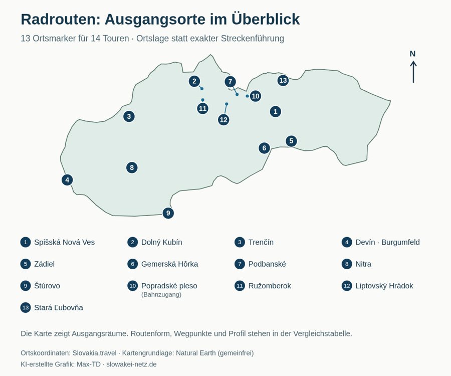
Starting areas for 14 cycling routes marked by 13 location markers; Trenčín is the starting point for two loops. AI-generated graphic: Max-TD; map data: Natural Earth (public domain). The markers provide geographic orientation; the routes are described in the table.
Share graphic
Shared links lead to this graphic and the related information on Slowakei-Netz.de.
Embed on your own website
The graphic may be shared and embedded under CC BY 4.0. The code includes image credit, Source: www.slowakei-netz.de and a licence link.
Select “Copy code” and paste the code into the HTML section of your website.
Slovakia: Cycling routes compared
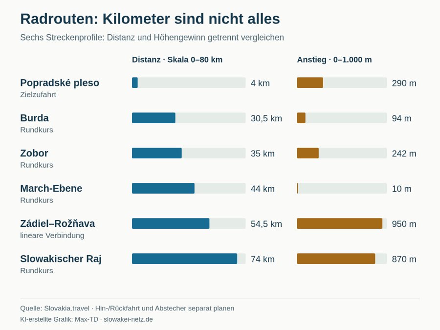
Distance and elevation gain for six cycling routes, with separate scales for kilometres and metres of elevation gain. AI-generated graphic: Max-TD; route data from Slovakia.travel. Return journeys and detours must be added to each point-to-point route.
Share graphic
Shared links lead to this graphic and the related information on Slowakei-Netz.de.
Embed on your own website
The graphic may be shared and embedded under CC BY 4.0. The code includes image credit, Source: www.slowakei-netz.de and a licence link.
Select “Copy code” and paste the code into the HTML section of your website.
